Skip to main content
The Record of Decision and Final Preliminary Section 4(f) Evaluation was published on Nov. 16, 2021 and can be found on the Documents page. This decision document identifies the Selected Corridor Alternative, which is a Build Alternative, and marks the end of the Tier 1 study.
The Selected Corridor Alternative is the same as the Preferred Corridor Alternative outlined in the Final Tier 1 Environmental Impact Statement published on July 16, 2021. The Selected Corridor Alternative is a 2,000-foot-wide starting point within which the proposed I-11 facility could be built.
 FHWA and ADOT Published the I-11 Final Tier 1 EIS
The Interstate 11 (I-11) Final Tier 1 Environmental Impact Statement and Preliminary Section 4(f) Evaluation (Final Tier 1 EIS) was made available for public review on July 16, 2021. The public review period for the Final Tier 1 EIS was 30 days and ran from July 16 through August 16, 2021.
The Final Tier 1 EIS document outlines a Preferred Corridor Alternative and the No Build Option. The I-11 Tier 1 environmental study is expected to be complete in late 2021 when the Record of Decision is issued by the Federal Highway Administration. That decision will include either the Selected Corridor Alternative or the No Build Option.
After the Tier 1 study is complete, Tier 2 environmental studies will be required. There is currently no schedule for the Tier 2 studies, and there is no funding allocated for those studies. There is also no timeline or funding allocated for construction of Interstate 11, should it move forward. If it does move to construction, it would be done in priority sections from Nogales to Wickenburg. ADOT could also construct Interstate 11 from Wickenburg to the Nevada state line to connect with I-11 Nevada, should funding become available to widen US 93 to interstate standards.
Incorporating Your Comments
The Interstate 11 study team has been busy since the public hearings and the public comment period held in mid 2019. The team continues to process more than 12,000 submissions received on the Draft Tier 1 Environmental Impact Statement (EIS) and the Recommended Corridor Alternative. Each submission is logged, evaluated by the project team, and sorted according to the topics covered in the comments and questions.
Ultimately, the Federal Highway Administration (FHWA) and the Arizona Department of Transportation (ADOT) will respond to public and agency comments on the Draft Tier 1 EIS when the Final Tier 1 EIS is published. The Final Tier 1 EIS will present a Preferred Corridor Alternative and the No Build Option. Finally, the Record of Decision from ADOT and FHWA will present either a Selected Corridor Alternative or the No Build Option.
If a Build Corridor is selected at the end of the Tier 1 process, then Tier 2 studies must take place as part of the National Environmental Policy Act process. These studies, which are not funded, would likely occur on priority segments along the 280-mile corridor between Nogales and Wickenburg.
Although the deadline for comments on the Draft Tier 1 EIS document has passed, comments on the Tier 1 EIS Study can be made at any time during the study process. All comments, regardless of when they are submitted, are reviewed and considered by the study team. The Final Tier 1 EIS document will include responses to comments on the Draft Tier 1 EIS document that were received during the April 5, 2019 through July 8, 2019 comment period. To leave a comment related to the Tier 1 EIS Study, visit the Contact Us page.
Comment Period Closes – What’s Next?
The 95-day public review and comment period for the I-11 Draft Tier 1 Environmental Impact Statement (EIS) concluded on July 8, 2019. Since April 5, 2019, when the document was released, more than 2,000 unique questions and comments on the Draft Tier 1 EIS have been submitted to the study team. In addition to those questions and comments, several thousand bulk emails were submitted to the study team as part of nationwide email campaigns from a few different organizations. The study team will provide responses to the questions and comments in the Final Tier 1 EIS, which is expected to be completed and released for public review in 2021.
Public Hearings Wrap Up – There’s Still Time to Comment
Nearly 1,350 people attended the six public hearings held throughout the 280-mile study area, and if you were one of them, thank you. If you weren’t able to attend, all the public hearing materials are on this website on the Public Meetings and Outreach page, and there’s still time to comment. The comment period closes on July 8, 2019, so please review the materials and submit your comments online.
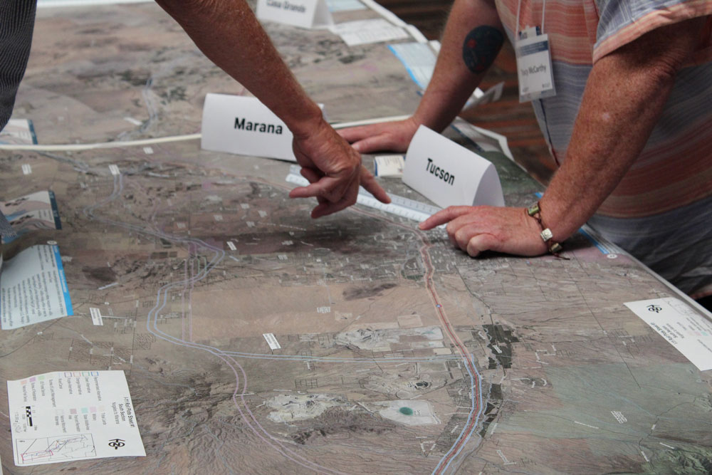
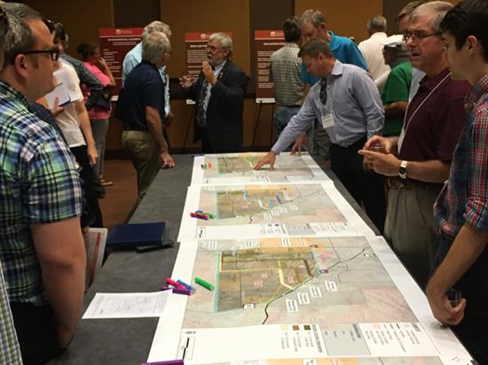
Attendees check out the corridor on a roll plot map.
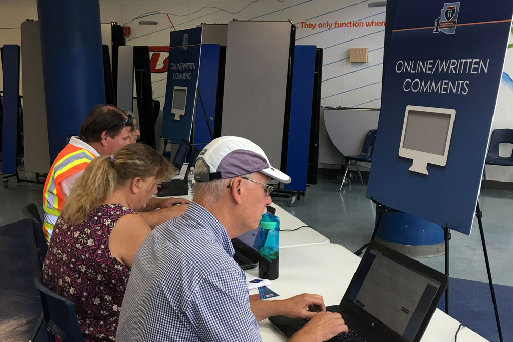
Attendees enter comments online.
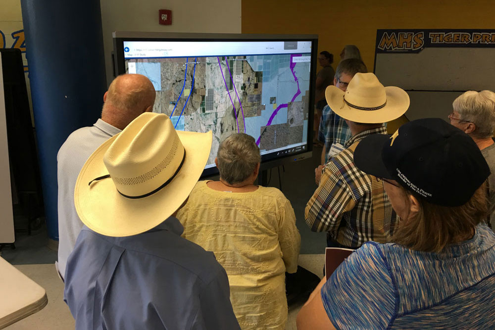
Attendees check out the touch screen map.
FHWA and ADOT publish Errata with the I-11 Draft Tier 1 EIS
On April 26, 2019, ADOT and FHWA issued an Errata (revised Chapter 4 and additional Appendix H1) to the Draft Tier 1 EIS. The revised Chapter 4 includes analysis not previously included in the Draft Tier 1 EIS released on April 5, 2019. To allow additional time for public review and comment on the Errata, the comment period was extended to July 8, 2019. Visit the Public Meetings and Outreach page for more information, including repository locations, and how to comment.
Public Hearings Scheduled
The I-11 Draft Tier 1 Environmental Impact Statement and Preliminary Section 4(f) Evaluation (Draft Tier 1 EIS) was released for public review and comment on April 5, 2019. Visit the Public Meetings and Outreach page for more information, including repository locations, and how to comment.
Where would Interstate 11 go?
At this point in the process, the Arizona Department of Transportation and the Federal Highway Administration (FHWA) have not determined a specific route for Interstate 11. A Recommended Corridor and the No Build Option have been identified in the Draft Tier 1 EIS. After a series of public hearings and a comment period seeking community input, a Preferred Corridor Alternative and the No Build Option will be identified in the Final Tier 1 EIS. This will provide another opportunity for public review. Finally, the Record of Decision by FHWA will present either a Selected Corridor Alternative or the No Build Option. This is expected in 2021.
2,000 vs. 400 feet wide
The Draft Tier 1 EIS presents a recommended 2,000-foot-wide corridor, along with the No Build (do-nothing) Option. For reference, a corridor is a 2,000-foot-wide swath of land. An actual freeway alignment is approximately 400 feet or less and would be determined during Tier 2 environmental studies. Tier 2 studies have not been funded or programmed yet.

Among the approximately 100 people who joined us Sept. 26 to talk about the Sonoran Corridor – a proposed highway that would connect Interstate 10 and Interstate 19 south of Tucson International Airport – there was some confusion over whether this effort is connected with a similar public involvement effort for the proposed Interstate 11 (I-11).
I-11 and the Sonoran Corridor have two key things in common: Both are proposed for southern Arizona, and both currently are the subject of environmental studies led by ADOT. In both cases, we are studying the social, economic and natural environment impacts that each proposed freeway would have on the surrounding areas to determine if there is an appropriate 2,000-foot wide corridors where we might locate each of these routes.
The proposed I-11 would be a north-south freeway between Nogales and Hoover Dam, possibly going in or near Tucson and the Phoenix area. The current study is looking for a corridor between Nogales and Wickenburg. North of Wickenburg, it likely would follow the route of US 93.
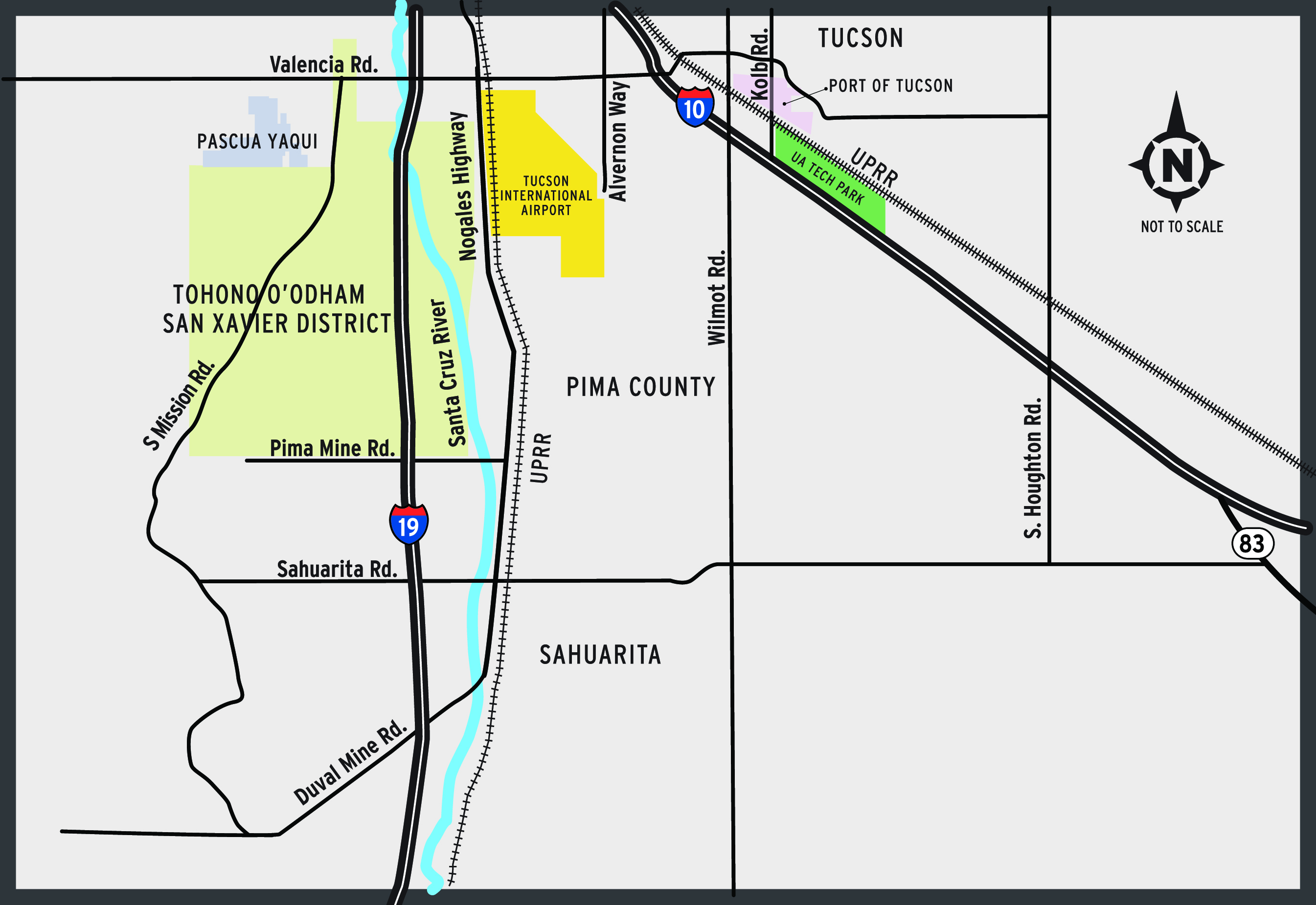
The proposed Sonoran Corridor would run east and west somewhere south of Tucson International Airport. It would be expected to relieve congestion on both I-19 and I-10 in central Tucson, reduce travel times and spur economic development.
These proposed highways have two more things in common:
First, both are years from construction. After ADOT completes Tier 1 Environmental Impact Statements, we would need to do Tier 2 studies to narrow the corridors to specific routes. We would then need to design each route and obtain the needed funding before any work could begin.
Second, we want to hear your thoughts on both proposals. Both project websites provide ways for you to share your thoughts (I-11 Tier 1 EIS Study and azdot.gov/SonoranCorridor). We hope you will.
Build Corridor Alternatives and the No Build Alternative
The previous post (What is a Tier 1 Environmental Impact Statement?, February 26, 2018) discussed the importance of identifying alternatives that meet the Purpose and Need of the project. The identification and analysis of alternatives are key to the process required under the National Environmental Policy Act (or NEPA). In addition to the proposed Build Corridor Alternatives, all NEPA studies must include a No Build Alternative. The No Build Alternative represents the do-nothing option or status quo, and is used as a baseline comparison and a viable option. So, what does that mean and how does it relate to the process (illustrated below)?
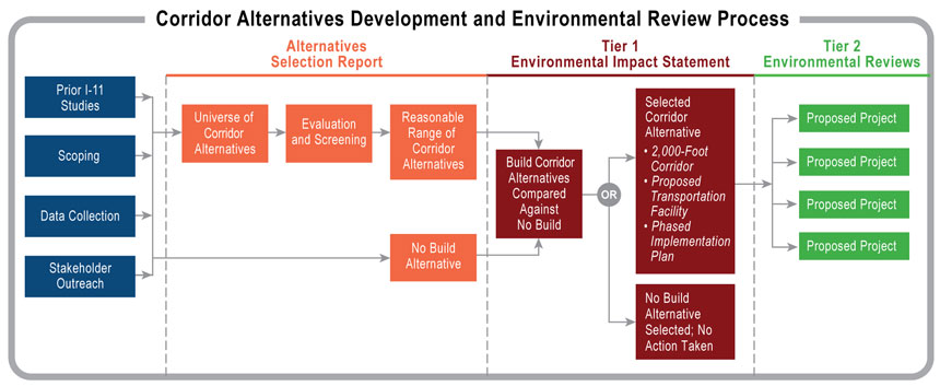
Build Corridor Alternatives
Build Corridor Alternatives are areas of land where an I-11 high-capacity transportation facility could be constructed to connect Nogales and Wickenburg. The Build Alternatives could include construction of a new corridor, modification of existing corridors, or a combination of both. Modifications to an existing corridor could include a variety of improvements, such as adding travel lanes, adding interchanges or changing the access (e.g., upgrading a highway to a freeway by discontinuing access to and from driveways and local streets).
Since this is a Tier 1 EIS, decisions will not be made regarding specific roadway features or improvements. Rather, each Build Corridor Alternative is a 2,000-foot-wide area within which the I-11 facility could be built. (A facility would be approximately 400 feet and would be specifically determined through Tier 2 studies.) The outcome of the Tier 1 EIS will be to select a Build Corridor Alternative to advance to subsequent studies, or to select the No Bbuild Alternative. Specific project activities and improvements needed to build a facility would be further evaluated once funding is identified in a future, more detailed and more design-specific Tier 2 NEPA environmental document.
No Build Alternative
The No Build Alternative means the proposed action – the implementation of the I-11 corridor - would not take place. For the I-11 Tier 1 EIS, it is the alternative in which no improvements related to the I-11 corridor would occur and the transportation system would remain “as is,” with the exception of improvements currently planned and funded in the State Transportation Improvement Program. The No Build Alternative is used as a baseline comparison, or a benchmark, to compare against the Build Corridor Alternatives. It is used to understand the condition of the Study Area in the future with no proposed action, and also to understand how a Build Corridor Alternative could influence the Study Area – for better or worse. Depending on the outcome of the I-11 Tier 1 EIS analysis, the No Build Alternative could be the most viable or acceptable solution and recommendation.
How do the alternatives relate to the Tier 1 EIS process?
The Tier 1 EIS will assess the Build Corridor Alternatives and the No Build Alternative to consider a wide range of potential impacts. For example, the Build Corridor Alternatives and the No Build Alternative will be studied in the Tier 1 EIS to characterize how they compare in meeting the transportation purposes of the project, such as improving travel times, and what potential environmental effects could occur with implementation of each of the Build Corridor Alternatives.
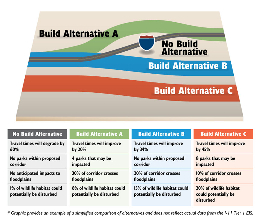
The following graphic shows an example of a simple comparison of alternatives. Note: This graphic is being used only for illustrative purposes and is not based on actual evaluation criteria or data. The graphic illustrates an existing interstate facility, three Build Corridor Alternatives, which include a combination of new corridors and their co-location with an existing facility, and a No Build Alternative. Generic evaluation measures show how potential environmental impacts may differ among alternatives and the types of considerations to expect in the Tier 1 EIS process.
For more information on how the current Build Corridor Alternatives were selected and advanced into the I-11 Tier 1 EIS for further evaluation, please see the Alternatives Selection Report at http://i11study.com/Arizona/Documents.asp.
What is a Tier 1 Environmental Impact Statement?
What Issues Are Considered in an EIS?
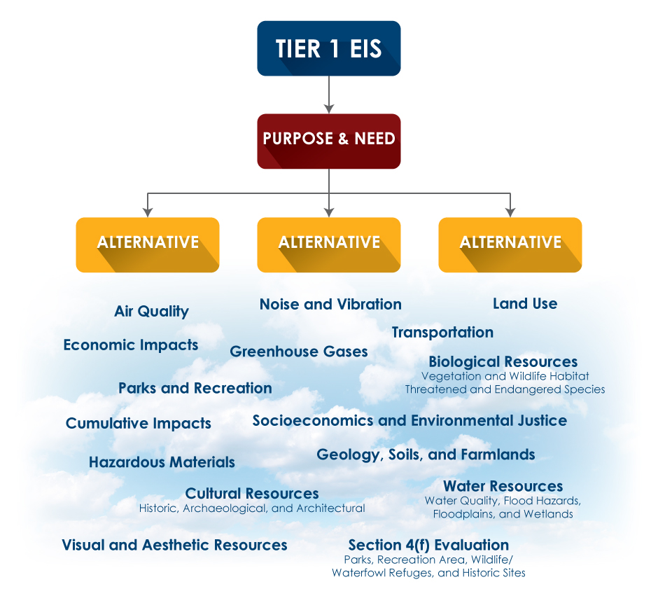
An Environmental Impact Statement, or an EIS, is a type of assessment required by the National Environmental Policy Act (NEPA) for federally funded or regulated projects. Of the different types of documentation, an EIS is considered the most thorough and considers all possible impacts of a proposed project – positive and negative – for many different resources.
An EIS requires a Purpose and Need statement, which outlines why the project is needed and what the project hopes to achieve. From here, the study team identifies various options for the Interstate 11 (I-11) Corridor (referred to as corridor alternatives) that meet this Purpose and Need. Information is gathered and analyzed for all alternatives, including a No Build alternative (or, a “do-nothing” alternative) to determine which alternative best meets the project’s Purpose and Need while causing the least negative impacts on the built and natural environments. When adverse impacts are predicted, the EIS would identify strategies to avoid, minimize, or mitigate impacts. Major resource areas analyzed are shown in the figure.
An EIS provides the federal agencies with the necessary information to make a decision regarding the proposed project and helps determine the potential consequences that could result from the project, what impacts can be mitigated, and which alternative best fits the Purpose and Need.
How Were the Alternatives Defined?
For the I-11 project, an Alternatives Selection Report (ASR) was published in December 2017 to document the development, evaluation and screening of a variety of corridor options from Nogales to Wickenburg. The ASR incorporated ideas and preferences on corridor options from local government agencies, tribes, stakeholders and the public. The ASR provides the basis for determining the alternatives to be evaluated in the Tier 1 EIS, which will analyze both Build Corridor Alternatives (i.e. alternative corridors from Nogales to Wickenburg that could move forward to construction), and a No Build Alternative (i.e., do-nothing option).
How Does a Tier 1 EIS Differ From a Traditional EIS?
The I-11 Corridor study team is in the process of completing a Tier 1 EIS. A Tier 1 EIS covers the same subject matter as a project-level EIS, only on a much more general scale. Typically, a Tier 1 EIS is used when funding has not yet been identified for a project or for managing the NEPA process across a large geographic area, such as the I-11 Corridor. A Tier 1 EIS involves technical analysis completed on a broad scale and is therefore an effective method for identifying existing and future conditions and understanding the comprehensive effects of the project on the region. It provides the groundwork for future project-level I-11 environmental and technical studies
A Tier 1 EIS allows the study process to move forward with no identified funding, while still laying the groundwork for where the corridor alternatives could be located. Project-level or Tier 2 environmental studies and identified funding sources would be required to advance construction of the project, which could occur in phases as funding is available. During Tier 2 studies, more detailed project elements would be defined and assessed, such as the specific alignment (the identified route) and the location of traffic interchanges.
For more information about the ongoing Tier 1 EIS, check out our latest fact sheet, which is published in both English and Spanish.
If you would like to be included on the I-11 mailing list to receive notifications of upcoming involvement activities and meetings, please notify us at [email protected] or subscribe for updates via the study website.
May 2017 Public Outreach – Feedback Summary
This past May, the Arizona Department of Transportation and the Federal Highway Administration conducted the second round of public outreach activities for the Interstate 11 environmental study. A total of six public meetings and four agency meetings were held to provide an update to those interested in the study and to gather their input.
This portion of the public outreach process supports the alternatives analysis for the I-11 Study and assists ADOT and FHWA in determining a reasonable range of alternatives to carry forward into the Draft Tier 1 Environmental Impact Statement for more detailed analysis.
The purpose of the May meetings was to solicit input on the universe of alternatives that was developed. This includes alternatives that the study team recommended for elimination and those still under consideration to be advanced into the Draft Tier 1 EIS.
The public meetings were held in Tucson, Marana, Nogales, Casa Grande, Wickenburg and Buckeye at schools and community centers. More than 600 people attended the meetings, with more than 2,300 comments gathered through June 2, which marked the end of the 30-day formal comment period.
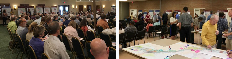
Meeting participants could leave comments on large table maps, on comment forms (written or electronic), at laptop stations, or via a court reporter. For those who could not attend in person, comments could be emailed, mailed or phoned in, as well as submitted via an online mapping and comment tool.
All meeting materials are currently posted on the study website under the Community Outreach and Public Meetings tab. Once complete, a summary of all comments received will be posted as part of the Agency and Public Information Meeting Summary Report. Also, upon completion, the study team will post the Alternatives Selection Report, which documents the alternatives analysis process, including how the agency and public feedback received was incorporated into the range of alternatives that will be carried into the Draft Tier 1 EIS for further study.
The next round of public involvement is expected to occur during summer 2018, following the release of the Draft Tier 1 EIS. This will include formal public hearings. Check the study website for regular updates from the study team..
If you would like to be included on the I-11 mailing list to receive notifications of upcoming involvement activities and meetings, please notify us at [email protected] or subscribe for updates via the study website.
Why I-11?
The concept of a high-capacity transportation facility connecting Canada and Mexico through the western U.S. has been considered for more than 20 years. It was initially identified as the CANAMEX Trade Corridor, which was outlined in the 1991 Intermodal Surface Transportation Efficiency Act, established under the North American Free Trade Agreement in 1993, and defined by Congress in the 1995 National Highway Systems Designation Act. In 2014, the Arizona Department of Transportation and the Nevada Department of Transportation jointly completed the I-11 and Intermountain West Corridor Study, with the purpose of determining whether sufficient justification exists for a new high-capacity, multimodal transportation corridor, and if so, to establish the likely potential routes.
The Federal Highway Administration and the Arizona Department of Transportation continue to study the I-11 Corridor in Arizona through preparation of the I-11 Tier 1 Environmental Impact Statement. An early step in preparing an EIS is to determine if transportation challenges or other needs exist in a defined study area – in this case, within the approximate 280-mile corridor between Nogales and Wickenburg. If the analysis demonstrates a clear Purpose and Need, the study process continues with evaluation of a reasonable range of alternatives to develop a solution that would best meet the Purpose and Need. In addition to these Build Alternatives, a No Build – or Do-Nothing – scenario will be assessed.
FHWA and ADOT have prepared a statement of the Purpose and Need for I-11, which is based on key transportation-related issues identified in previous studies, and which have been refined through agency coordination and public involvement during the scoping process (May-July 2016). The Purpose and Need statement is available on the Study Documents page.
How You Can Be Part of the Decision-Making Process for the Interstate 11 Environmental Study
The Federal Highway Administration and the Arizona Department of Transportation will be preparing a Tier 1 Environmental Impact Statement for the Interstate 11 Corridor from Nogales to Wickenburg in compliance with the National Environmental Policy Act and other regulatory requirements. NEPA was enacted by Congress in December 1969 and signed into law in January 1970. It was the first major environmental law in the United States that established the nation’s environmental policies. Under NEPA, federal lead agencies, such as the FHWA, are required to consider impacts of a proposed action on social, cultural, natural and economic resources.
The environmental review process under NEPA also provides an opportunity for you, the public, to be involved in the decision-making. It helps you understand what is being proposed; allows you to offer your thoughts and ideas on alternative ways to accomplish what is being proposed; and seeks your comments on the potential environmental effects and possible mitigation required for the proposed action.
Community members have valuable information about places and resources that they value and the potential effects that proposed actions might have on those places and resources. NEPA provides you with multiple opportunities to work with the FHWA and ADOT so they can take your information and feedback into account.
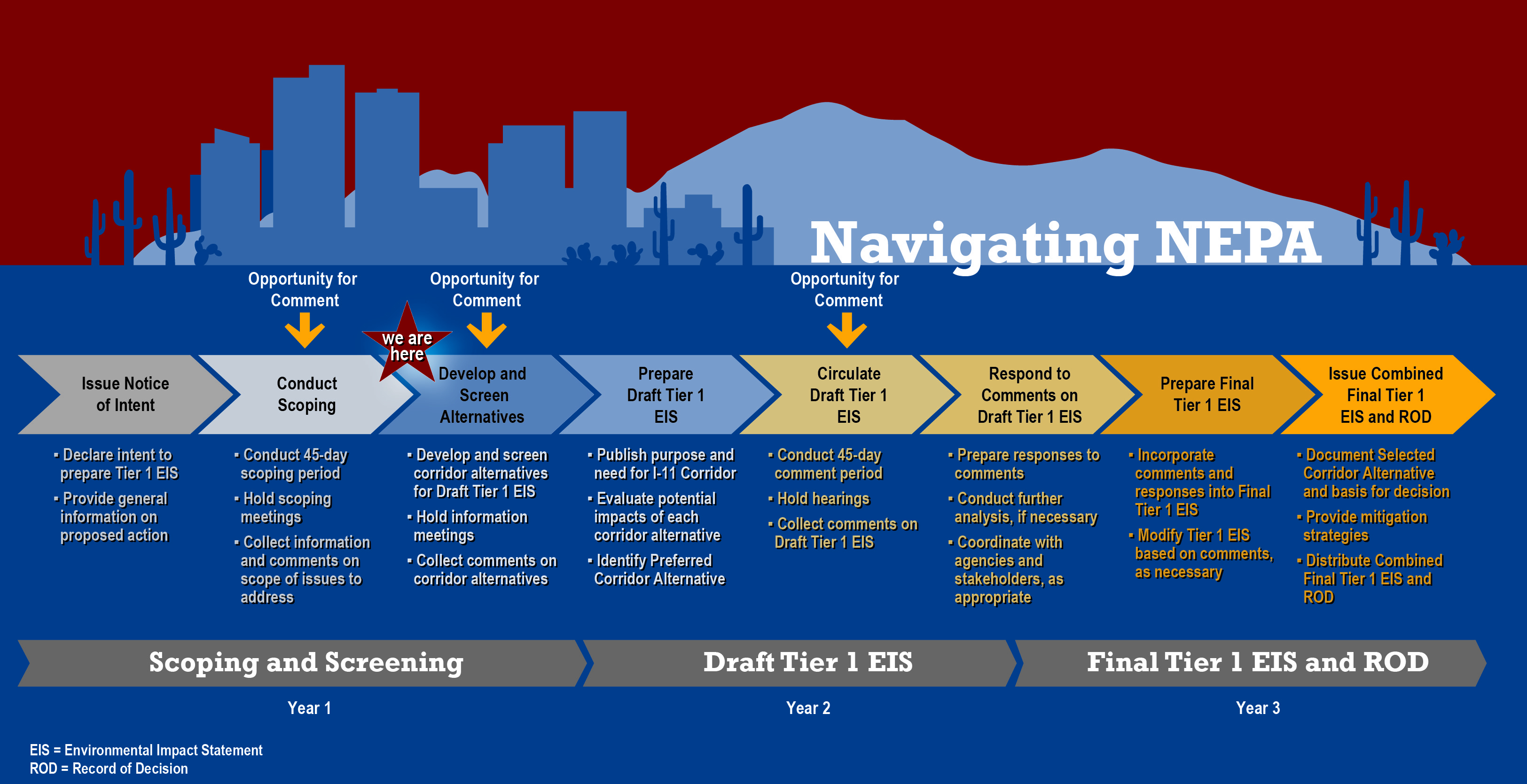
The graphic below shows the general steps of the environmental review process in preparing the Tier 1 EIS, including the opportunities for public and agency comments. We have completed the second step shown on the graphic (Conduct Scoping) and are now moving into the next step.
We Asked, You Answered: Scoping Summary
Scoping is an early, important step in the environmental review process. During scoping, the public and agencies have an opportunity to share their ideas and concerns, which help determine the “scope” or range of issues to be addressed in the environmental document, also referred to as the Tier 1 Environmental Impact Statement.
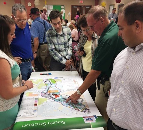
The Federal Highway Administration and Arizona Department of Transportation held six public scoping meetings between June 8th and June 29th at locations throughout the corridor study area, including Casa Grande, Buckeye, Nogales, Tucson, Marana, and Wickenburg. A total of 540 people participated in the meetings. Attendees were encouraged to share verbal and written comments, as well as mark suggestions on maps of the 280-mile-long corridor study area.
In addition to the scoping meetings, the public had an opportunity to submit comments through an online survey and by e-mail, mail or voicemail. In total, 834 public comments were received through these outreach methods. Three agency scoping meetings were also held to obtain input from federal, state, regional, county, local and tribal governments. The meetings were held in Phoenix, Casa Grande and Tucson, with 23 agencies in attendance.
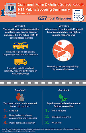
Members of the public who completed a comment form or online survey were asked to rank potential issues and human and environmental factors from 1 to 5, with 1 being the most important and 5 being the least important. The graphic to the right summarizes the ranking results from the 657 people who completed a comment form or online survey. For the complete list of questions asked of study participants during scoping, please see comment form.
Other written and verbal comments were received about environmental concerns, potential corridor alternatives, multimodal considerations, economic development, and other issues. The full Scoping Summary Report will be posted on the study website in the coming months. Check the i11study.com website for regular updates from the study team.
The feedback received during the scoping process will help the FHWA and ADOT identify the purpose and need; potential corridor alternatives to be studied; impacts to be evaluated; and evaluation methods to be used during the development of the I-11 Tier 1 Environmental Impact Statement. This is only the beginning – the public and agencies will continue to be engaged throughout the study.
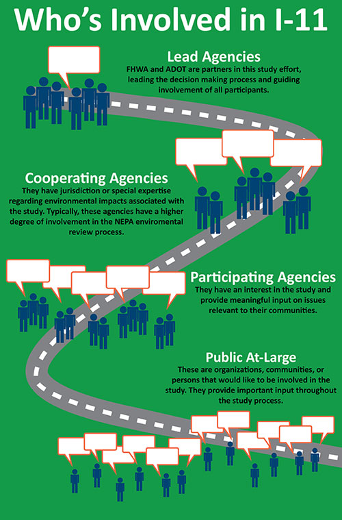
Here’s who is involved in I-11
It takes many people, from the planning phase through construction, to take a proposed project like Interstate 11 from an initial concept to a transportation solution. With a three-year environmental study that began recently for a corridor between Nogales and Wickenburg, here’s a quick rundown of who’s involved.
The Federal Highway Administration is the federal lead agency and the Arizona Department of Transportation is the local study sponsor for the ongoing Tier 1 Environmental Impact Statement required under the National Environmental Policy Act. Together, they lead the environmental review process and guide involvement from others.
These include federal agencies with jurisdiction or special expertise regarding environmental impacts. Other agencies or tribal governments may also qualify if the Federal Highway Administration concurs. Cooperating agencies typically have a higher degree of involvement in the environmental review process.
Certain federal, state, tribal, regional and local agencies with an interest in the study provide meaningful and specific insights. The role of participating agencies is broader and less involved than that of cooperating agencies.
These partners range from other agencies to organizations to individuals who wish to be involved. These stakeholders tend to have specific interests in the study, such as living or working in the study area. This effort could not be done without their participation and involvement.